Mavina kere mapping: Kolar O Mittur
Water is life, and on the surface, lakes play a vital role in fulfilling not only the drinking needs but for every activity that surrounds the water. Its dependence is such that in a rural setup, the whole economy's fate is decided by how easy is the water available in the region.
In this blog, I will narrate our visit. We visited Kolar on 13 June 2022 as a group of three participants (Kishlay, Sanobar, and Srishty). The district is around 60 km from the city of Bangalore. We located two lakes in the region. We roamed the lake by going a full round of it.
We asked important questions to the village woman traveling with us, Yashodamma, a farmer, and another village lady.
We had two agendas
To mark the physical features of GPS
To understand the other socioeconomic and political aspects
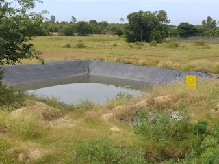
Figure: Krishi Honda
Picture of Lake taken from Bund

The first lake we covered had 27 acres of land. The first plantation we saw was of Jowar, which was grown for fodder. It's not a water-intensive crop. Then we saw small mulberry crops. It supports the silk industry. We understood how wastewater could be used for the harvest, and silk is non-edible.
The lake had fish. Each lake is given a fishing contract, and they give it to the panchayat for the contract so that no one else can steal fish from that lake. A person also resides in the hut near the lake to look after it.
The water comes from the hillside, which acted as the catchment.
We saw a dried borewell and also a new borewell which supplied water to the whole village. For recharge of the borewell, we saw a square structure.
While walking on the lake bund, we saw different types of fodder for the cow and also saw a private farm pond or "Krishi Honda", covered with plastic. We went there, took photos of it, and marked the location.
One part of lake rejuvenation had a budget for Naga stones used to worship Lord Ganesha and Naga habaa. The stones were found while rejuvenation was thus collected. Some snake-carved stones were used for worship too. If a Cobra is found in the village, they don't kill it as they worship it. Otherwise, they may kill other snakes.
We saw lantana camara, which is native to Australia, and also saw parthenium or Congress grass. Both are very invasive and get huge in size if left. They were used as firewood earlier, but after the free gas scheme of the Central govt, it's not used now.
We saw an erstwhile well under it, a feeder channel used for canal irrigation. There was a metal device used to control the water flow and its direction. The level of the lake can be managed through that. A "tubu" is a well that can be controlled to let the water out. It wasn't functional. Nearby there was a pump house. There was a drain-like structure below it. There was an opening that could lead to water flowing through it.

Figure: Mango tree
We also recorded the locations of the pump houses, borewells, and Naga statues. The outflow was then visible, so we noted it. As we walked along the bund, we made a note of the position. A tailorbird nest was visible close to the lake. We also noticed paddy farms. Due to lake rejuvenation, even a parched location like this now has 100 quintals of rice for each household. Prior until today, only a small number of laborers were employed to harvest rice for the Reddys and the Brahmins. Numerous native and exotic breeds of goats and buffaloes have been domesticated. The water from the lake is also used by the villagers' animals. This demonstrates the assurance in the lake's water quality.
We saw the lake's command area and catchment. Even when cows are forced to graze in the catchment area by herders, this is unquestionably not overgrazing. Herders must be given some money to establish equity in the event that they don't let their animals graze in the watershed and offer environmental services for the wealthy landlords downstream.
In the waste weir, the water can exit the lake in one of two ways: either by overflowing when it fills up or by controlling soil erosion using the slope. The first lake was known by the names Raj Kalua (Lake), Kodi (way for water), and Maawin Kede, and the second lake, Badwan Kede, was created after the first lake overflowed. The word "badwan" is a community in the SC, therefore it might be connected to them. The caste gap has widened recently. Asha, who directs an NGO in the village for the socio-economic advancement of women and children, also brought this up.
On the route, we saw numerous pump houses and borewells. In order to determine the water level by how long it takes for a pebble to create a sound, we dropped one inside the borewell. Only a 2-second pause allowed us to hear it, indicating a healthy groundwater level.
We also recorded the pebble experiment on video. The borewell had been enclosed.
s= ut + ½ a * (t)^2 0 * 2 + 10 * 2 * 2 = 40 meters depth ( Since u=0) We asked a villager she told us the depth was around 10 meters depth so we can conclude the lake helped in increasing the ground water level of the region in general.
We observed several recently planted trees, and we learned that even after the monsoon, water reaches this location. Even if all trees are resistant, they can all be submerged and yet be safe. The Jakkur lake, in contrast to this lake, was naturally shaped like a bowl and could take any shape depending on the weather, with the exception of the side facing the bund, which provides its shape through blocking. For the area, June is still the pre-monsoon season.
They used the lake rejuvenation to create an Ambedkar statue and left behind money worth ₹28000. The crops like Nilgiri and Eucalyptus that cover the lake's edges provide a serious problem for the lake. They continued to grow them since they brought in a large profit from their oil, but doing so uses a lot of water and has a significant impact on groundwater levels. Since they are Southern Hemisphere natives, they require more water even in summer in Northern Hemisphere nations like India.
They were previously planted specifically to dry up the lake. To gain a sense of the fragrance, we inhaled the Eucalyptus leaves.
The lake's edge was next to some private property, which is where we discovered it. Private landowners used to farm right next to the lake before lake rejuvenation, but a fence was built as a result of government action. The encroachment was also repositioned. The Karnataka government's JSYS, or Jala Samvardhane Yojana Sangha, program was involved. It was a World Bank-sponsored undertaking. We could also think of thorny bushes and jagged leaves as barriers.
In contrast to other far-off lands, the soil surrounding the lake was more clay and silty. Thanks to the lake, the depth of the groundwater in the area around it was only around 10 feet.
.

Figure: Grazing Buffaloes
On the way, we once more noticed a chameleon. The residents had to object as well because Kolar is generally not a productive region and is also very susceptible to drought. But things are considerably better now that the lake has been rejuvenated and there have been strong rains for three to four years.
After that, we took note of the inlet's location. Before, everyone drank water straight from the tap, but now since most people have borewells, they don't. However, individuals who work nearby also utilize the lake water for drinking, but they do so from a different location than where the animals do.
On the journey, we came across bamboo, mango, guava, Indian gooseberry, and Jamun trees. The location where the wooden scraps were collected would naturally decompose into manure.
We learned that dogs drink water when we noticed a dog's footprint next to the lake. We discovered tractor or truck type marks that demonstrate dirt mining. The mined earth was also visible to us. One further inlet caught our attention; it was so large that a check dam had been erected above it.
Additionally, we witnessed some trees being taken down. The area along the bund is where the stone-throwing was done. A borewell was visible not far from the lake, but it had dried up. This demonstrates how shallow aquifers have water but deep ones may not.
The inlets we covered the most were on the higher side of the watershed. When we next encountered a farmer, he told us about how he used to graze his three buffaloes in the watershed. For water, they were reliant on the lake.
We stopped at a fishermen's hut on the opposite lake and talked about local problems there for a while. We were able to see how effectively NGO and government collaboration worked. Recognized how the neighborhood used Grameen Bank to save money and borrow money. Additionally, how one NGO assisted in the sale of spice powders produced by local women. All government programs created just for them benefit them.
Even the neighborhood participated in the lake cleanup by establishing five groups. They will clean a kaluve themselves if one is close by.
Written by Kishlay Ranjan.
Bihar, India.
No comments:
Post a Comment