Monday, 27 June 2022

Hosakere lake

 Hosakere lake

Hosakere lake is situated in the Pichaguntahalli village of Kolar district in Karnataka. The total area of the lake is 19.18 acres.from last 2 year lake is maximum full to its capacity in august and september. The lake was desilted in 2003( JSYS+ world bank) and in 2021 slit is added back to the fields . as they are rich in nutrients. There is always a requirement of desiltation in the 8 to 9 year in a lake but it happens here after almost 18 year.for the desiltation process the local villager came forward to help in the process. The lady with whom we had interacted had more than 20 years of knowledge in the field of lakes. The demand can be made to the gram panchayat by the people for the betterment of the village. The daily Wages in the village is 297 to both men and women in the village by Nrega scheme.

Hose kere, Pichaguntahalli - Google Maps 


Downstream of the lake is Doddakere, Yalagondahalli and upstream is Talakunte. Water came from the Talakunte to the lake. 


Kolar is one among six permanently drought-prone districts in Karnataka. In 15 years to 2015, only three years in Karnataka–2005, 2007 and 2010–witnessed no drought, as per a 2017 Karnataka State Disaster Management Monitoring Centre’s drought vulnerability assessment report. The district has zero net groundwater for future use, and has the highest groundwater extraction – 211% – in the state, noted the 2017 Dynamic Groundwater Resources Assessment of India. The month with the most rainfall is September.


3 feeder channels coming from the catchment area are in use while one feeder channel is not in use anymore.


Feeder channel not in catchment area           


                       Feeder channel in catchment area


Feeder channel in catchment area 


Around 48 families live around the lake. Everyone around the lake and in the village uses the lake: farmers for irrigation, herders for cattle grazing, children for swimming and women for washing clothes and No, sewage does not enter directly into the Lake. The drip pipe has been provided to the small and marginal farmers by the government and everyone has adopted the drip irrigation system. Paddy and ragi are the crop cultivated in command area, There is a shift from manual cutting of paddy to machines. 50 people were required to cut paddy. The daily charges were Rs 400 per day for 4 to 5 hours. The machine achieves to cut paddy for over 1 acre in Rs. 4000. The machines have reduced the extra financial burden of the farmers. Crop grown in catchment areas is Beans,Tomato,Green chili. Sand mining was observed. Villagers extract mud to use in house foundations as well. This leaves depressions in the lake and affects the flow of water through the lake.


Waste weir of the lake


Wells


This farm has a private well 10 ft in diameter and 20 ft in depth. The well has 3 ft of parapet wall around it.


This farm well is 15 ft in diameter and 30 ft depth the well is completely filled with the water till the ground level and resembles

a pond.


Public farm well- 12 ft dia, 60 ft. This stone pitched well was built more than 50 years ago in two months with the help of 4 people.

The local language to measure the well is ‘murmuttu’ in the village. 1 murmuttu is equal to 20 feet.


Income resources of the villagers are agriculture, dairy and quarry. Quarry located on the east and south east side of the lake.


Quarry (east)


Quarry (South east)


Biodiversity Observations:

Trees: Peepal, Neem, Eucalyptus, Tamarind, Lantana Camara, Babool, Knotweed, Calotropis, Alchornea

Wetland plants: Typha, Alligator weed

Mammals: Mongoose, dog.

Birds: Pied wagtail, Spot-billed ducks, Jungle myna, Bee Eater, Silverbill, White-rumped swallow, Gray heron, Pond heron,  Purple herons, Pied kingfisher, Black drongo, Black-headed ibis, Red-wattled Lapwing, Paddyfield Pipit, Little cormorant, Shikra

Reptiles/ Amphibians: Rock Agama, toad, frogs

Insects: Butterfly, Damselflies, Dragonflies, spiders.


Bean


Lantana camara


                                               Rock gam


                                               Typha


The correlation between the Tank system and Bengaluru's Topography

Bangalore District is located in the southeast of Karnataka State, in the centre of the South Deccan plateau, between the latitudes of 12° 39' North and 13° 18' North and the longitudinal meridian of 77° 22' East and 77°52' East. It has an area of about 2,191 square kilometres and an average elevation of about 910 metres (Bangalore rural and urban districts)

The Bangalore North taluk is more or less a level plateau and lies between 839 to 962 meters above mean sea level. In the middle of the taluk there is a prominent ridge running NNE-SSW. The highest point (Doddabettahalli 962m) is on this ridge. The gentle slopes and valleys on either side of this ridge hold better prospects of ground water utilization. The low-lying area is marked by a series of tanks varying in size from a small pond to those of considerable extent, but all very shallow.

Bangalore South Taluk represents an uneven landscape with intermingling of hills and valleys with bare rocky outcrops of granites & gneisses raising 30-70 meters above ground level are common in the southern portion. The highest point is 908m above mean sea level and the lowest at 720 meters above the mean sea level. Southern and Western portions present a rugged topography composed of Granitic and Gneissic masses. The eastern portions of the Taluk form an almost featureless plain with minor undulations.

Fig. 1: Bangalore's changing slope topography is depicted on a slope map as per percentage.

Contour lines are used to represent elevation. An elevation is represented by a contour line when it is drawn on a map. The elevation of each point on the map that touches the line should be the same. You can tell the height of a line on some maps by the numbers on the lines. Different altitudes will be represented by contour lines placed adjacent to one another. The slope of the terrain increases with the proximity of the contour lines to one another.

Fig. 2: Bengaluru's contours are shown on a map every 50 metres.
Interconnected tanks were made possible by the area's undulating geography, which ranged in altitude from roughly 600 m to about 962 m AMSL. Due to the abundance of tanks (approximately 285 tanks in a 161 sq km area, Bangalore's spatial extent , the city was once rightly referred to as the "city of tanks." To permit the transfer of excess water to the following lake, these tanks were all connected by canals and drains (kaluveys). These tanks served the region's fundamental requirements, including supporting food production (fish, etc.) and agricultural activity. They also provided drinking water for the community and habitat for fish and other aquatic ecosystems.
Bangalore City's naturally undulating landscape, which includes hills and valleys, is ideal for the creation of tanks that catch rainfall, store it for later use, and guarantee ground water replenishment. Thus, tanks are dynamic ecological systems that are essential for the survival of all species, including humans. When a lake in Bangalore overflowed, the extra water would flow into the next lake in the cascade because tanks in Bangalore were constructed in a cascade from higher to lower elevations. Along the land's natural gradient, water flows both north to south-east and north to south-west. There is a central ridge in the center of the region with maximum elevation 943, Minimum elevation 600 and average elevation in Bangalore city is 910 as per shown in Fig. 3. 

Fig. 3: Topographic variations in Bangalore city according to elevation

The elevation map depicts the land's varying elevations showing central ridge in the center of the region. Contour lines are used to represent elevation. An elevation is represented by a contour line when it is drawn on a map. The elevation of each point on the map that touches the line should be the same. You can tell the height of a line on some maps by the numbers on the lines. Different altitudes will be represented by contour lines placed adjacent to one another. The slope of the terrain increases with the proximity of the contour lines to one another
By holding vast volumes of water and releasing it when there is a shortage, a lake functioning properly can lessen the effects of floods and droughts. Additionally, tanks recharge groundwater and improve the water quality of downstream watercourses. Tanks often raise the lowest temperature year-round while lowering the maximum temperature. Bangalore has cooler climate because its elevation is more than 900 m above sea level. The more you go upward from earth’s surface, the average yearly temperature of a place decreases. That is the only reason. Any place of similar elevation (and located in a similar latitude) will be as cool as Bangalore.

TANK SYSTEM OF BANGALORE CITY

Interconnected tanks were made possible by the area's undulating geography, which ranged in altitude from roughly 600 m to about 962 m AMSL. Due to the abundance of lakes (approximately 285 tanks in a 161 sq km area, Bangalore's spatial extent , the city was once rightly referred to as the "city of Lakes." To permit the transfer of excess water to the following lake, these tanks were all connected by canals and drains (kaluveys). These tanks served the region's fundamental requirements, including supporting food production (fish, etc.) and agricultural activity. They also provided drinking water for the community and habitat for fish and other aquatic ecosystems.
In a city like Bengaluru, which lacks a perpetual river and is dependent on several tanks for both water supply and leisure, tanks are particularly crucial. On the city's uneven landscape, several tanks have been built over many years. Its geography makes it easier to use the tanks since it made it possible to create a chain of tanks that feed into one another and provide enough water. Tanks are beneficial for recharging groundwater as well

Fig. 4: Bengaluru's Lakes connectivity

VALLEY SYSTEM OF BANGALORE CITY
Fig. 5: Bangaluru’s major Valleys

Kormangala-Challaghatta Bangalore, which is situated on a ridge, has three valleys that serve as watersheds: the Koramangala Challaghatta Valley (K&C Valley), the Hebbal Valley (H Valley), and the Vrishabhavati Valley (V Valley). K&C valley, which spans an area of 255 square kilometres inside the boundaries of Bruhat Bengaluru, is the biggest, followed by Hebbal valley (207 square kilometres), and Vrishabhavati valley (165 square kilometres). While Vrishabhavati Valley enters the Arkavathi River, a tributary of the Cauvery River, both K&C Valley and Hebbal Valley unite at Nagondanahalli Village and run on to the Dakshina Pinakini River.

Through its tributaries Arkavathi, Pinakini or Pennar, and Shimsha, Bangalore's drainage system transports water to the River Cauvery. The region's centre, north, and east are undulating, with tracts of highland covered in scrub and a series of tanks created by enclosing streams in the valleys in the low areas. Small ponds and huge tanks of various sizes may be found in these valleys. The land's southern region is made up of closely spaced hills that are encircled by dense rainforests.
Valley houses many tanks and play a very important role in its hydrological processes. Thus, in each of the three valley systems, the tanks create a chain of reservoirs. Small streams are born in each valley near the ridge's summit. In three valleys, they cascade to create significant stream networks. The tanks in Bangalore are therefore stored in the valleys, and the tanks are connected to one another by a network of chains, creating a cascade effect across the entire system.

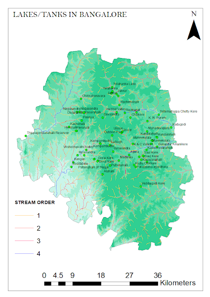
WATER STREAM CONNECTING LAKES/TANKS

Stream ordering is a method of assigning a numeric order to links in a stream network. This order is a method for identifying and classifying types of streams based on their numbers of tributaries. Some characteristics of streams can be inferred by simply knowing their order.
The highest stream order is sixth order in the Vrishabhavathi Valley basin, whereas the highest stream order in the other two Valleys is fifth order. It was found that the valley systems created a dendritic drainage pattern. 
The Vrishabhavathi Valley is elongated in shape, but the K-C Valley and the Hebbal Valleys are less elongated in shape, according to the watershed shape factor.
The drainage density of the three Valleys showed that they are classified as having coarse drainage density. The three Valleys' relief features provide modest reliefs that suggest a flat terrain

 
Fig. 6:  Bangalore's water stream map, with the fourth-highest stream order and the first-lowest stream order

The above study provides a possibility to work further on several Bangalore lake series depending on their stream order.
- Composed by: Chidambari Kulkarni


Ecological Cost of Water


Source: https://www.newyorker.com/tech/annals-of-technology/where-the-water-goes

Water is the primary resource that supports a country's socioeconomic development. The exploitation and utilization of water resources have promoted national economic development but have seriously endangered the sustainability of water resources. Some of the major water-related issues are as follows:

  • Water overuse

  • Water pollution

  • Water stress due to urbanization

  • Unsustainable practices

  • Lack of efficient management

  • Climate change

Causes of Overexploitation of water


  • Failure to implement water resource policies

  • Lack of awareness among customers

  • Incentives favor economic growth over environmental conservation (GDP)

  • Lack of social responsibility among companies

What are Ecological Costs?

Eco-costs are a measure to express the amount of environmental burden of a product on the basis of prevention of that burden. The costs which should be made to reduce the environmental pollution and materials depletion to a level that is in line with the carrying capacity of our earth.

What is Environmental Accounting?

Environmental Accounting is the process of recording, analyzing, and reporting financial and ecological effects on corporate organizations to address environmental issues. Using accounting information systems, recognized as management control systems, could integrate accounting, statistics, environment, and economic development to maximize water resource utilization. A financial information system built on social responsibility accounting could strengthen enterprises’ social responsibilities for environmental protection.

Direct ecological costs

  1. Assessment costs for baseline studies, environmental impact analysis and the preparation of Environmental Impact Assessment (EIA) studies.

  2. Prevention costs incurred in operations that prevent environmental impacts.

  3. Mitigation costs for both new and existing facilities or activities, like control of emissions, effluents and discharges.

  4. Reclamation costs for returning the site of activity and surrounding affected areas to a state “agreed on”.

  5. Compensation costs to affected parties for irrecoverable damage to the environment.

Indirect ecological costs

Indirect costs include the depletion of natural resources, environmental components on water, soil, and habitat; and conservation and efficiency of resource utilization. External environmental costs are those that cannot be accurately measured in monetary terms and assumed by enterprises.

What is the ROI?


  • An effective environmental cost accounting of water resources could solve the problems of water quality deterioration and water environment destruction.

  • Enabled companies and their partners in the supply chain to gain significant cost savings from environmental considerations.

  • Reduce their operating costs, better price the products as well as save natural resources.

  • Implementing eco-efficiency indicators has assisted them to use more efficient energy and resources in developing their products.

  • EMA is associated with innovation and cleaner production. Thus, it leads to increased shareholder value and improved firm reputation.


EMA Tools

Some available techniques of EMA can be employed to meet the specific need of entities,

namely costing analysis, investment appraisal and performance management.


The EMA tools include: 

  • Life Cycle Assessment  (LCA), 

  • Activity-Based Costing (ABC), and

  • Material Flow Accounting,  

  • Total Cost Assessment  (TCA), and

  • Environmental  Balance Scorecard (EBS) or 

  • Sustainability Balance Scorecard (SBSC).


In terms of Water

In terms of water, direct costs include the price of water, operational costs and investments in water infrastructureThe second is indirect costs like environmental fines, insurance premiums, and legal and corporate social responsibility costs

Finally, there are costs related to risks, which could include the financial consequences of water shortages, flooding, financial such as credit ratings and regulatory risks, and even reputational risks.


Defects in the Water Supply Infrastructure

The direct costs of water depend on the networked water supply infrastructure including factors like the source of water, transport distance to the treatment plant, treatment process, transportation to the city and distribution channels. These also include operation, maintenance costs, and sinking funds. Indirect costs would also include water lost due to leakages in pipes or tankers.

Issues with respect to water management in cities:

  • Monopoly of the water sector, rural areas tend to receive less water

  • Poor communication among the different departments within water supply organizations like BWSSB

  • Water is expensive and inaccessible to the poor

  • Lack of regulators and monitoring of tariffs


In peri-urban areas of Bangalore, farmers are aware that their lands would be taken over by municipal corporations. They grow cash crops and sell wood, used for scaffolding in houses. Borewells on these lands extract water and supply it to the city via tankers. Hence, depleting the ecological value of the land completely. 


Again, there is no sense of responsibility regarding water management and the importance is given to the economic value of the land.


Rainbow Drive Layout


The Rainbow Drive layout is a private gated residential 34-acre-layout. On all the built-up plots, a total of 258 households are residing and around 90 households are tenants. The layout did not have any formal water supply from the Bengaluru’s water utility, the BWSSB and completely depended on its borewells as a water source.


The Plot Owners’ Association took various measures to tackle water problems:

  • Ban of digging private borewells and residents depend on community borewells alone 

  • The POA invested in community recharge wells, integrated with storm water drains. (3 feet in diameter and 20 feet in depth)

  • Efforts were made to undertake an outreach and engagement program to the wider resident community of Rainbow Drive about the benefits of rainwater harvesting.

  • The residents were given the option to have household recharge wells or sponsor a recharge well in the community. They provided a discount of Rs 100 to the people who have done household RWH system.

  • To reduce water wastage, consumption meters for each household and a tariff of Rs 6/ KL were introduced in 2006. Later, it was found that the water tariff only accounted for the electricity used to pump borewell water. It did not account for the maintenance costs of bore wells, or the costs of cleaning the water tanks, waterproofing leaks, or fixes to faulty piping. Most importantly, it was found that the cost of treating sewage was not accounted for in the household water bill at all. The true production cost of water was determined to be Rs. 25 per kilolitre.

  • In 2015, they employed NEERI’s Phytorid Technology to treat wastewater. The technique uses anaerobic digestion, followed by a root zone treatment.

    Source: http://bengaluru.urbanwaters.in/wp-content/uploads/sites/3/2018/10/Biome-GSI-Paper-Citizens-demonstrate-water-management-solutions-for-the-city-2.pdf


Benefits achieved :
  • The groundwater table has risen to 250 ft and recharge wells have been able to reduce flooding during monsoons. 

  • The freshwater demand per house has reduced significantly. From 280 to 150 LPCD

  • Using the Phytorid technology has reduced the energy cost of treating water. It has achieved a savings of Rs 80,000/- per month on operations costs. 

  • The total estimated recharge of the layout now exceeds the groundwater withdrawn from its borewell. Two borewells provide 1.3 lakh liters of water every day. 80 KL of water is treated at the STP and reused within the community.


Solutions for the City Level


  • A decentralized strategy

  • Citizens should demand management through education and appropriate tariffs on water, rainwater harvesting and groundwater recharge for flood control and groundwater sustainability, and, wastewater treatment and reuse to reduce freshwater demand and ensure responsible discharge of wastewater.

  • Retail meters in every legal connection to monitor water consumption and collect tariffs accurately. So, if consumes more water he should pay through and increase the block tariff.

  • The cost of treating wastewater should also be taken into the account according to the polluter pays principle.

  • A constant flow of information and a dialogue with the politicians and citizens of the city would help everybody understand what the future holds for them in a water-constrained city.


Wastewater- Lakes in the Kolar district

Treated water from Bangalore flowing into a lake in Kolar
More than 300 million liters per day of a targeted 440 MLD is being transferred from Bengaluru to the adjoining, parched district of Kolar and parts of Chikkaballapur through the Koramangala-Challaghatta Valley project. This water is then pushed into 126 lakes scattered around Kolar, many of them left dry by successive droughts. The purpose of the project is to rejuvenate the depleted groundwater in the drought-hit Kolar region.


Investments/ Costs

  • De-silting of the lake and feeder channels

  • Maintenance of wells and bunds, sluice gates, etc

  • Tree planting in the catchment area

  • Impact of the Quarry in the catchment


Benefits 

  • An increase in the water levels in the wells

  • Amount of crops grown

  • Cash crops

  • Fishing


By Sneham Pandey and Prajwal Chendkapure