Monday, 27 June 2022

Rain gauge (Working principles and DIY)

Rain Gauge

A rain gauge is a meteorological instrument to measure the precipitating rain in a given amount of time per unit area. The instrument consists of a collection container which is placed in an open area. The precipitation is measured in terms of the height of the precipitated water accumulated in the container per given time and is expressed in millimeters. Rain gauges are great tools to use for monitoring changes in precipitation over time.


How it works:


Anyone can make a standard rain gauge. All you need is a cylindrical tin/steel box. The cylinder should have millimeters marked on the side and a funnel of an equal diameter on top. The rain is collected in the cylinder via the funnel and the water level is measured using the scale. While quite effective and simple, this gauge has some accuracy issues.


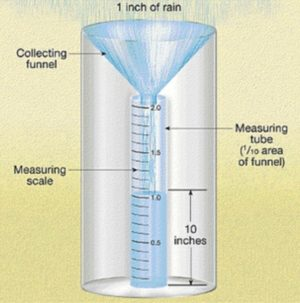
To tackle this, the funnel rain gauge was developed. It consists of a funnel-shaped collector and a measuring tube. The area of the collector is 10 times that of the tube; so the reading is magnified by a factor of 10. This measuring tube is suitably marked to accommodate this magnification. Measurement in both these types is done manually and the protocol is to measure at 8.30 a.m. daily.

Many different types of rain gauges have been developed over time. Automatic rain gauge systems were originally developed to collect rainfall data at remote locations, where logistics prevented regular visits. These are now widely used for their accuracy and also because they can give live readings that are very useful in the era of climate change.


Different Types Of Rain Gauge:


Measuring rainfall can be primarily done in three different ways using three different types of rain gauges. The three major types of rain gauges are the standard gauge, tipping bucket gauge and weighing gauge. Further distinguishing aspects such as how they are set up and how they deliver data can be made, though the basic operation of rain gauges does not usually vary from these primary rain gauge types.


1)The Standard Rain Gauge:


The recording of rainfall using the standard or funnel rain gauge is generally done manually. These gauges work by catching the falling rain in a funnel-shaped collector that is attached to a measuring tube. The area of the collector is 10 times that of the tube; thus, the rain gauge works by magnifying the liquid by a factor of 10.

Magnifying the rain in this way allows precise measurements down to a one-hundredth of a mm. Amounts that exceed the tube capacity are caught in the outer shell of the gauge, allowing the recorder to pour out the liquid in the tube and fill it back up if needed.

2)The Tipping Bucket Rain Gauge:


The operation of a tipping bucket rain gauge is quite different from the standard gauge. The receiving funnel leads to one of two small buckets. Filling of one bucket occurs at one-hundredth of a mm. The result is a “tipping” of the liquid into the outer shell of the gauge, triggering the second bucket to take its place. 

The process then repeats itself, allowing for precise measurement of rainfall intensity and amount. This gauge has become standard for wireless weather stations


3)The Weighing Rain Gauge:


The universal weighing rain gauge is optimal for climatology use. This is because of a vacuum that accounts for the effects of wind, allowing more rain to enter the gauge. These gauges are very precise in measuring rainfall intensity as the weighing mechanism at the bottom of the collector can be used to measure depth and time simultaneously. Recording is carried out much in the same way as the older versions of the tipping bucket gauges.


Site Selection For Rain Gauge:

While selecting the site for the installation of rain gauge the following points should be take kept in mind.

  1. The site should be in levels ground and other types of the ground like hilltops,  hill slope, etc undulation type of slope is not suitable.
  2. The site should be an open space.
  3. The nearest object from the rain gauge should be kept at a distance of twice the height of the object.
  4. The gauge  should be away from continuous wind forces.
  5. Other meteorological instruments and the fencing of the site should maintain step 3 above.
  6. The site should be easily accessible.
  7. The gauge should be truly vertical.
  8. 10% of the total number of rain gauge stations of any basin should be self-recording.
  9. The observer must visit the site regularly to ensure its proper reading readiness for measurements.


DIY Rain Gauge:

STEP 1: gather the following materials: 1 plastic bottle (1.lt), 1 pair of scissors and tape(duct tape, transparent tape, etc).

STEP 1


STEP 2: cut the plastic bottle at the top just before it starts to narrow as shown in the image below
STEP 2

STEP 3: use this cut out part as a funnel to be placed in the plastic bottle
STEP 3

STEP 4: Usually bottoms of water bottles are never flat, therefore draw a line near the base just before it starts to narrow. Now cut a strip of tape and place it on the side of your gauge. With the help of a marker and a ruler, mark off every millimeter until you reach the top of the gauge
STEP 4

STEP 5: Pour pebbles and water up to the line drawn at the bottom of the gauge, this will help give some stability to the rain gauge.

STEP 5

STEP 6: your rain gauge is now ready to be used. Place your rain gauge outside on a leveled and flat surface. It is best to place the rain gauge at a height where there are are no obstructions such as branches or people walking by.
Record the readings at 8:00am everyday for accurate measurement.
STEP 6


Calculating the Amount of Rainwater Capturable from Your Roof:


Step 1: What is the Rainfall in Your Area? Before you can estimate how much rain you can potentially harvest month-to-month or in a year, you need to know how much rain could fall from the sky. This can be found out with the help of a rain gauge.

Step 2: Calculate Surface Area of Your Roof. Since rainwater is collected from rooftops, you will need to work out the total surface area of roof/s (in meter)  that will be used to catch rainwater. 

Step 3: Calculating Your Harvestable Rainwater. To calculate how much rainwater can be harvested, multiply your rainfall (mm) by your roof surface area (m2) being used to catch rainwater. The resulting number represents how many litres of water you can expect to collect.

Conclusion:

Traditional rain gauges and weather stations at an individual scale across any city or landscape can help in understanding localized weather phenomena and help us interact with the weather more efficiently and effectively in it. 

There are around 100 people who study rainfall in their own homes through the traditional rain gauges. Around 50 homes and offices have installed the automatic weather instruments (Bangalore, 2017)

  • Maintaining a Healthy Landscape by Watering Your Plants and Grass

  • How to Spot Local Weather Trends and Patterns

  • Understanding When to Plant

  • Understanding the Risk of Flooding

  • Gaining a More Accurate Picture of Rainfall


Refer to the presentation for an overview 

References:

- Rohith, Shivani, Sadhana


Reviving Traditional water management practices or constructing more modern-day dams to tackle water scarcity – A dilemma for Bihar.

From Indian perspective

India is facing major water scarcity, which is challenging its food security. There is constant debate on whether to build more big dams to tackle the issue or go back to centuries-old traditional water management practices. Megaprojects like the Interlinking of rivers and the building of big dams did one thing in common, they made people shy away from century-old cost-effective traditional water management techniques. These megaprojects come up with displacement of tribals and other indigenous communities, and loss of biodiversity, and livelihoods, but managed to project themselves as a solution to India's ongoing water scarcity.  

Bihar’s ongoing water crisis

At least eight of the 38 districts in the Bihar have significantly low groundwater levels, according to an assessment by the state's Public Health Engineering Department (PHED). According to the same assessment, at least 11 of the districts fall under the "water-stressed" category.

According to a different survey, the government owns almost one-fourth of the water bodies in the Ganga basin, and they have all dried up. While just 56 percent of the water bodies in the area were functioning, the survey conducted by the Quality Council of India (QCI) in collaboration with ASSOCHAM, CII, and FICCI found that 16% of the water bodies in the area were eutrophic. It examined 578 water bodies in the Ganga Basin and discovered that 411 were encircled by populated areas.

Ahar pynes in Bihar (Traditional water harvesting structure)

Bihari farmers created the ahar-pynes agricultural method to adjust to the unpredictability of the climate in the area. The concept involves digging channels (called pynes) into the ground that allow water to flow while having high embankments on either side. Small retention ponds (called ahars) that are used to catch extra water are dotted around the waterway. The system's architecture has two functions: it retains water during droughts and drains water during floods.

Figure: Ahar Pyne system of Bihar

The benefits of ahar pynes

On the edges of the channel and around the ponds, crop-yielding patties can be planted thanks to the system. When the technology is used properly, farmers may be able to grow two crops per year, enhancing food security and generating additional revenue. These systems were managed by the community, and there was a sense of ownership that existed within these ecologically safe traditional water systems. The major stakeholders were people involved in decision-making in the system. The zamindars were primarily in charge of these.

The neglect of ahar pynes

There was a decline in these systems because of lack of funding, management change after India's independence, abolishment of zamindari, or negligence and abandonment. In contrast, unlike big dams and interlinking of rivers, these systems did not displace communities, harm flora, and fauna, or affect livelihoods. However, in the past, they helped the communities endure water stress and droughts. 

The drawback of ahar pynes

even though they can, in part, alleviate the existing water shortage in Bihar. We cannot ignore the reality that they depend on "rainfall," and the ensuing three dry seasons can render these buildings utterly dry and unable to store water for irrigation.

The benefits of modern-day dams

Megaprojects like dams, meanwhile, guarantee water supplies all year round, even during successive drought seasons. They do not dry up following consecutive dry seasons.

Figure: The dam 

Image source: The splash.

The drawbacks of the dam.

·       Damming and flooding river basins have resulted in many environmental issues.

·        Big dam has led to local and indigenous people displacement.

·        Fish community alteration and the disappearance of commercial fishery practices are all well-known global impacts of Big Dams

·       Loss of biodiversity, loss of natural and agricultural terrestrial ecosystems.

·       Emission of greenhouse gases into the atmosphere, particularly methane.

Even when people and social activists object to the building of dams and the idea of interlinking rivers, we can see massive dam construction ongoing and politicians and policymakers projecting interlinking rivers as the solution to water scarcity, especially in water deficit areas.

A balance between traditional harvesting structures and modern projects

Having seen the advantages and disadvantages of both traditional water systems (such as the ahar pynes in Bihar) and megaprojects, we can assume that we do not have to completely disregard the two; rather, with all of their advantages and disadvantages, these two methods are crucial for  Bihar to fight ongoing water scarcity.

Reference:

1. https://en.wikipedia.org/wiki/Ahar_Pyne

2. https://www.downtoearth.org.in/news/water/bihar-staring-at-water-crisis-in-summer-months-with-groundwater-levels-declining-76174#:~:text=Published%3A%20Friday%2026%20March%202021,'%20category%2C%20the%20report%20said.


By: Sanobar Imam
Bihar, India.

Mavina kere mapping: Kolar O Mittur


Mavina kere mapping: Kolar O Mittur

Water is life, and on the surface,  lakes play a vital role in fulfilling not only the drinking needs but for every activity that surrounds the water. Its dependence is such that in a rural setup, the whole economy's fate is decided by how easy is the water available in the region.

In this blog, I will narrate our visit. We visited Kolar on 13 June 2022 as a group of three participants (Kishlay, Sanobar, and Srishty). The district is around 60 km from the city of Bangalore. We located two lakes in the region. We roamed the lake by going a full round of it. 

We asked important questions to the village woman traveling with us, Yashodamma, a farmer, and another village lady. 

We had two agendas 

  • To mark the physical features of GPS

  • To understand the other socioeconomic and political aspects 


               Figure:  Krishi Honda

  Picture of Lake taken from Bund


The first lake we covered had 27 acres of land. The first plantation we saw was of Jowar, which was grown for fodder. It's not a water-intensive crop. Then we saw small mulberry crops. It supports the silk industry. We understood how wastewater could be used for the harvest, and silk is non-edible. 


The lake had fish. Each lake is given a fishing contract, and they give it to the panchayat for the contract so that no one else can steal fish from that lake. A person also resides in the hut near the lake to look after it. 


The water comes from the hillside, which acted as the catchment. 


We saw a dried borewell and also a new borewell which supplied water to the whole village. For recharge of the borewell, we saw a square structure.


While walking on the lake bund, we saw different types of fodder for the cow and also saw a private farm pond or "Krishi Honda", covered with plastic. We went there, took photos of it, and marked the location. 


One part of lake rejuvenation had a budget for Naga stones used to worship Lord Ganesha and Naga habaa. The stones were found while rejuvenation was thus collected. Some snake-carved stones were used for worship too. If a Cobra is found in the village, they don't kill it as they worship it. Otherwise, they may kill other snakes. 


We saw lantana camara, which is native to Australia, and also saw parthenium or Congress grass. Both are very invasive and get huge in size if left. They were used as firewood earlier, but after the free gas scheme of the Central govt, it's not used now. 


We saw an erstwhile well under it, a feeder channel used for canal irrigation. There was a metal device used to control the water flow and its direction. The level of the lake can be managed through that. A "tubu" is a well that can be controlled to let the water out. It wasn't functional. Nearby there was a pump house. There was a drain-like structure below it. There was an opening that could lead to water flowing through it.


Figure: Mango tree


We also recorded the locations of the pump houses, borewells, and Naga statues. The outflow was then visible, so we noted it. As we walked along the bund, we made a note of the position. A tailorbird nest was visible close to the lake. We also noticed paddy farms. Due to lake rejuvenation, even a parched location like this now has 100 quintals of rice for each household. Prior until today, only a small number of laborers were employed to harvest rice for the Reddys and the Brahmins. Numerous native and exotic breeds of goats and buffaloes have been domesticated. The water from the lake is also used by the villagers' animals. This demonstrates the assurance in the lake's water quality.


We saw the lake's command area and catchment. Even when cows are forced to graze in the catchment area by herders, this is unquestionably not overgrazing. Herders must be given some money to establish equity in the event that they don't let their animals graze in the watershed and offer environmental services for the wealthy landlords downstream.


In the waste weir, the water can exit the lake in one of two ways: either by overflowing when it fills up or by controlling soil erosion using the slope. The first lake was known by the names Raj Kalua (Lake), Kodi (way for water), and Maawin Kede, and the second lake, Badwan Kede, was created after the first lake overflowed. The word "badwan" is a community in the SC, therefore it might be connected to them. The caste gap has widened recently. Asha, who directs an NGO in the village for the socio-economic advancement of women and children, also brought this up.


On the route, we saw numerous pump houses and borewells. In order to determine the water level by how long it takes for a pebble to create a sound, we dropped one inside the borewell. Only a 2-second pause allowed us to hear it, indicating a healthy groundwater level.


We also recorded the pebble experiment on video. The borewell had been enclosed.

s= ut + ½ a * (t)^2 0 * 2 + 10 * 2 * 2 = 40 meters depth ( Since u=0) We asked a villager she told us the depth was around 10 meters depth so we can conclude the lake helped in increasing the ground water level of the region in general.


We observed several recently planted trees, and we learned that even after the monsoon, water reaches this location. Even if all trees are resistant, they can all be submerged and yet be safe. The Jakkur lake, in contrast to this lake, was naturally shaped like a bowl and could take any shape depending on the weather, with the exception of the side facing the bund, which provides its shape through blocking. For the area, June is still the pre-monsoon season.


They used the lake rejuvenation to create an Ambedkar statue and left behind money worth ₹28000. The crops like Nilgiri and Eucalyptus that cover the lake's edges provide a serious problem for the lake. They continued to grow them since they brought in a large profit from their oil, but doing so uses a lot of water and has a significant impact on groundwater levels. Since they are Southern Hemisphere natives, they require more water even in summer in Northern Hemisphere nations like India.

They were previously planted specifically to dry up the lake. To gain a sense of the fragrance, we inhaled the Eucalyptus leaves.


The lake's edge was next to some private property, which is where we discovered it. Private landowners used to farm right next to the lake before lake rejuvenation, but a fence was built as a result of government action. The encroachment was also repositioned. The Karnataka government's JSYS, or Jala Samvardhane Yojana Sangha, program was involved. It was a World Bank-sponsored undertaking. We could also think of thorny bushes and jagged leaves as barriers.


In contrast to other far-off lands, the soil surrounding the lake was more clay and silty. Thanks to the lake, the depth of the groundwater in the area around it was only around 10 feet.

.


Figure: Grazing Buffaloes 


On the way, we once more noticed a chameleon. The residents had to object as well because Kolar is generally not a productive region and is also very susceptible to drought. But things are considerably better now that the lake has been rejuvenated and there have been strong rains for three to four years.


After that, we took note of the inlet's location. Before, everyone drank water straight from the tap, but now since most people have borewells, they don't. However, individuals who work nearby also utilize the lake water for drinking, but they do so from a different location than where the animals do.


On the journey, we came across bamboo, mango, guava, Indian gooseberry, and Jamun trees. The location where the wooden scraps were collected would naturally decompose into manure.

We learned that dogs drink water when we noticed a dog's footprint next to the lake. We discovered tractor or truck type marks that demonstrate dirt mining. The mined earth was also visible to us. One further inlet caught our attention; it was so large that a check dam had been erected above it.


Additionally, we witnessed some trees being taken down. The area along the bund is where the stone-throwing was done. A borewell was visible not far from the lake, but it had dried up. This demonstrates how shallow aquifers have water but deep ones may not.


The inlets we covered the most were on the higher side of the watershed. When we next encountered a farmer, he told us about how he used to graze his three buffaloes in the watershed. For water, they were reliant on the lake.


We stopped at a fishermen's hut on the opposite lake and talked about local problems there for a while. We were able to see how effectively NGO and government collaboration worked. Recognized how the neighborhood used Grameen Bank to save money and borrow money. Additionally, how one NGO assisted in the sale of spice powders produced by local women. All government programs created just for them benefit them.


Even the neighborhood participated in the lake cleanup by establishing five groups. They will clean a kaluve themselves if one is close by.

Written by Kishlay Ranjan.

Bihar, India.


Spark Park

 Spark Park

Sustainable development places a strong emphasis on the idea of ‘Cradle to Grave’ or  ‘Kasadinda Rasa’ a Kannada expression which means Treasure out of Trash. We have spent our childhood wearing clothes of our elder brothers and sisters and hence we do have some sense of the recycling concept.

What if we extrapolate the very same concept to improve natural resource management which is the need of the hour considering the impact the fast pace development has had on our environment. 

Now, one of the natural resources whose management affects each and every one of us equally is Water. The effect can be felt directly or indirectly depending on whether we are living in water stressed area or a relatively water abundant area but sooner or later the problem is going to affect us all. The problem of water scarcity is not limited to its consumption; with the increase in extreme events due to climate change, the areas which once received heavy rainfall now face drought like conditions and the areas which earlier faced water shortage now get flooded in an event of more than average rainfall.

Urban gardens provide an effective way to manage water resources by regulating water levels. Apart from regulating the water resource, urban parks also help to improve air and soil quality, they help in maintaining biodiversity, act as compost sites for local biodegradable waste and can also help in the regulation of micro climate. Local authorities like the MLAs and the municipalities play a crucial role in park development and maintenance by actively providing technical and financial support.

But the local authorities are not the only ones who have contributed to the development of parks and gardens around the city, citizen’s contributions have also led to the establishment of many gardens and the rejuvenation of many more around the city.

 One such park is Spark in Doddanekkundi which falls under the jurisdiction of BBMP. Spread across 3.5-4 acres, the park was initially a Tennis Academy. After the academy’s lease expired, the park turned into a wasteland, receiving all sorts of waste from nearby areas. But thanks to the collective efforts of the people and administration, the park was revived. The initial funding from the DBS bank and WIPRO helped in improving the deteriorating condition of the park. DBS bank helped with the plantation of 500 saplings. The saplings were all of the different types starting from Jamun, Jackfruit, and Mango to Lemon, Neem, Peepal and Mahogany.

Funds were also made available through people’s voluntary contributions and an MLA helped in the installation of pipes and establishment of recharge pits across the park.3 STP pipelines were set up in the park which received sewage treated water from 3 nearby resident societies; the water received is used for gardening purposes. 9 recharge pits, all of which are interconnected, are used for storing rainwater which ultimately helps in maintaining the groundwater levels. 

However, the park is not without its challenges. We could identify 3 broad challenges facing the park: Stormwater management, old eucalyptus trees adding to the existing water pressure and further funding opportunities. There is a huge scope for collecting data on rainfall patterns and people’s consumption patterns and decisions can be taken in future based on the collected data.


References:


  1. https://www.dnaindia.com/bangalore/report-from-kasa-to-rasa-koramangala-shows-the-way-1493903


  1. https://www.deccanherald.com/city/bengaluru-infrastructure/hc-bars-graphite-india-from-selling-prime-land-in-whitefield-993143.html


https://www.deccanherald.com/specials/point-blank/waste-segregation-at-source-still-a-work-in-progress-1083036.html

Friday, 8 October 2021

Water management at a house in Bengaluru

The water management practices of an individual house in Bengaluru, Vijaya Bank Layout are described in this post. This house is in the Bilekahalli ward of Bengaluru and receives BWSSB water supply twice a week.


Before delving into the details, it was essential to actually understand the layout and structure of the house. For this, a layout diagram of the house was made.

C1 & C2: Grated collecting pipes for rainwater 

T: Overhead tank for storing water 

S1: Borewell of approx 250’ depth 

S2: Sump for storing BWSSB Kaveri water 

S3: Recharge well of 6’ depth 

M: Water meter 

C: Connecting pipe for rooftop collected rainwater 

From this layout diagram, it can be seen that the house has a sump for storing the BWSSB water which is then pumped onto the terrace and used for their daily needs. There is also a borewell of 250’ depth. But the water in this borewell had gone dry about 5 years ago. This time when the borewell was inspected, there was water at a depth of about 56’ from ground level, which means a total of 194’ of standing water! But how did this happen?

This is where the humble recharge well comes into the picture.

Testing the water level in the borewell

Recharge well

If one looked at this recharge well, they would never be able to say that it’s capable of recharging about 1893 litres of water in one day! With a depth of 1.83 m, this recharge well has shown us that size really doesn’t matter. It was dug about 3 years ago. Water from the rooftop is collected and flows into this recharge well which has an unlined bottom. This means that the water from this well recharges the groundwater.

Recharge well with the inflow pipe

Representative sketch of the recharge well

After monitoring the rate of recharge in this well, we have found that it recharges water at the rate of 0.023 litres/sec, and even on days with extremely heavy rainfall, this recharge well has never overflowed.

Now, after 3 years of digging this well, we have seen that the water in the borewell has increased. While it is also important to monitor the rainfall of the city and understand if there are any other sources of recharging the borewell, it is also pretty clear that this recharge well has an important role to play in this.

One of the most fascinating things that was learnt from this analysis is that although the BWSSB Amendment Act states that households with the requisite rooftop area must have a recharge well of 10 ft depth, we see that this 6 ft recharge well does just as well as any other recharge well.

Water demand

Finally, the water demand and areas of usage was analysed. And it showed that this household has a daily water demand of 191.5 litres/capita/day, which is slightly on the higher side. But several recommendations to reduce the water demand were given. Further, it was also suggested that the borewell water be used for the non-potable purposes in the house, to reduce reliance on BWSSB water.  

References 

Rain Water Harvesting - Bangalore Water Supply and Sewerage Board. Bwssb.karnataka.gov.in. Retrieved 17 September 2021, from https://bwssb.karnataka.gov.in/new-page/Rain%20Water%20Harvesting/en


Gayathri Narasimhan